Meteorologists are warning of a potential “super El Niño” this year, which could become the strongest climate event of its kind in over a decade. The National Oceanic and Atmospheric Administration (NOAA) indicates a significant probability that Pacific Ocean temperatures will rise at least 1.5 degrees Celsius above average, triggering extreme weather shifts globally. While the phenomenon often brings devastating droughts to some regions and torrential storms to others, experts suggest that early detection provides a critical window for nations to prepare for the resulting environmental and economic disruptions.
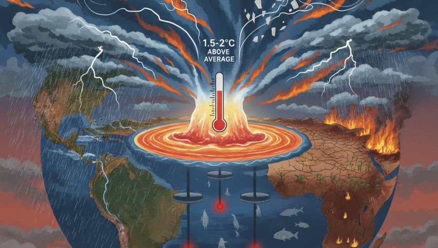
The National Oceanic and Atmospheric Administration recently increased its confidence that El Niño conditions could emerge as early as this spring or summer. Current projections suggest a 50 percent chance of a “strong” event and a 25 percent chance of a “very strong” or “super” El Niño. This rare classification occurs when surface temperatures in the tropical Pacific Ocean soar to at least 2 degrees Celsius above historical averages. The last such event took place nearly a decade ago, contributing to the hottest global temperatures ever recorded at the time.
This climate pattern, which has influenced the planet for millions of years, typically lasts between nine and twelve months. It begins when the trade winds that usually blow from east to west across the Pacific weaken. This allows warm water to surge toward the coasts of Ecuador and Peru, altering atmospheric circulation worldwide. Scientists monitor these changes using a sophisticated network of satellites and deep-sea buoys, which deploy probes more than 300 meters underwater to track heat accumulation beneath the surface.
The consequences of a powerful El Niño are far-reaching. By pushing the jet stream further south, the pattern often brings increased rainfall to the southeastern United States and Texas. Conversely, regions such as southern Africa, Indonesia, and Australia frequently face severe droughts and heatwaves, which can lead to crop failures and devastating wildfires. Beyond human impact, the phenomenon disrupts marine ecosystems; previous strong events caused massive declines in the Galápagos penguin population as warming waters depleted essential nutrients and fish stocks.
However, the shift in global winds can offer some relief in other areas. Researchers at Colorado State University predict a near or below-average Atlantic hurricane season this year, largely because El Niño generates strong vertical wind shear that can tear developing storms apart. While the potential for extreme weather remains high, experts emphasize that the predictability of El Niño allows for better strategic planning. Rather than viewing it as a purely negative force, scientists see it as a recurring cycle that provides a clearer roadmap for navigating upcoming environmental challenges.